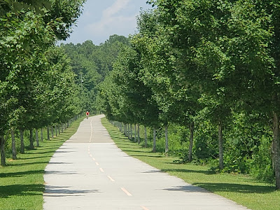
The Cumberland Valley Rail Trail currently stretches from Shippensburg, PA to Newville, PA. Work is underway to extend the trail into Carlisle. A short section is apparently open now in Carlisle. I rode the trail in August of 2019. I started in Newville. There appeared to be a finished trail in the direction of Carlisle but is was marked with trail closed signs.
The trail was crushed gravel on one side and grass for horseback riding along the other side. Some portions of the trail did not include the horseback option. A short section at Newville was paved and a longer section at the Shippensburg was also paved. Cyclists of all ages are supposed to wear a helmet when riding this trail.
Luck was on my side in my choice of Newville for a start. It appeared to be a very gradual incline all the way to Shippensburg. It certainly felt easier on the return. There were a few road crossings and some had curves or hills making visibility less than ideal. The section I rode was 10 miles one way. It was well used but not crowded.
The trail passes mostly agricultural land that was mostly planted with corn this season. Near the half way mark was some electric fence along the trail. This area is apparently for some goats to graze. I think this was the first time I saw goats along a bike trail. Even with fields on both sides of the trail, the trail itself was generally shaded by a canopy of trees.
I was appreciative of the clean, modern rest room at the ends of the trail. The Shippensburg end was at the university and included sculptures, a railroad museum, parking and an attractive rest room facility.
To see a video of my ride visit Marks Bike Tock on YouTube. https://youtu.be/CHuaD_qPMT8 and https://youtu.be/biv8rs8Y5Co
For more information about the trail visit the website for Cumberland Valley Rail Trails Council.
Pictures and experiences cycling bike trails in northeastern Pennsylvania and beyond.
Silver Comet Trail
I was in the Atlanta area so I had to make time to visit the well known, Hall of Fame trail The Silver Comet Trail. The trail is over sixty miles long in Georgia but connects to the 30+ mile Chief Ladiga Trail in Alabama. I only had the chance to do a bit over 10 miles but it was a most enjoyable experience.
The trail section I rode was near the Atlanta end starting near MM 5. I rented a bike from Comet Trail Cycles. The bike was excellent and the price was very reasonable. This trail section was mostly shaded, very welcome in the Georgia heat. I got to see bamboo trees for the first time along with some birds I was not able to identify. They were back and forth to nests that appeared to be made of mud stuck to the underside of a bridge.
The trail section I cycled was flat except for a couple of bridges over roads. The surface was paved with asphalt or concrete with a yellow line down the middle. The yellow line reminded users to keep right except to pass and it did its job. There were many access points both public and private. Trailheads generally had rest room facilities and water fountains.
It is my understanding that there is a large trestle and a tunnel further up the trail.
Additional information about the trail may be found at http://www.silvercometga.com/ You can watch a short video of the trail on MarksBikeTock on YouTube: https://youtu.be/v5c4BPwu-MM
The trail section I rode was near the Atlanta end starting near MM 5. I rented a bike from Comet Trail Cycles. The bike was excellent and the price was very reasonable. This trail section was mostly shaded, very welcome in the Georgia heat. I got to see bamboo trees for the first time along with some birds I was not able to identify. They were back and forth to nests that appeared to be made of mud stuck to the underside of a bridge.
The trail section I cycled was flat except for a couple of bridges over roads. The surface was paved with asphalt or concrete with a yellow line down the middle. The yellow line reminded users to keep right except to pass and it did its job. There were many access points both public and private. Trailheads generally had rest room facilities and water fountains.
It is my understanding that there is a large trestle and a tunnel further up the trail.
Additional information about the trail may be found at http://www.silvercometga.com/ You can watch a short video of the trail on MarksBikeTock on YouTube: https://youtu.be/v5c4BPwu-MM
Warwick to Ephrata Rail-Trail
Warwick to Ephrata Rail-Trail is a relatively new trail
located in the heart of Pennsylvania Dutch country. News accounts indicate the trail opened in fall of 2018 but I believe portions were open prior to this. Both ends of the trail pass
residential areas mostly above back yards. Most of this area has a buffer of
trees along the trail making it less intrusive. The middle section of the trail
passes through farm land offering beautiful views.
The trail is a bit short for cycling at about 7.5 miles. Since it is located on farmland, the trail has minimal elevation changes and I found no discernable difference cycling in either direction. The
ends in the area of Ephrata and Warwick are paved and shaded, the middle
section is smooth, crushed gravel with considerably less shade. There are porta
potties placed at several locations along the trail. When I visited late in the
morning on a Friday I found the trail well used but not so much to be
considered crowded.
If you plan on visiting you should note that most businesses
in the area are closed on Sundays. My wife and I were reminded of this when we
visited on a Sunday and tried to find a restaurant open for lunch. We were very
hungry by the time we finally found one.
You can find a nice pdf map of the trail here: https://www.ephrataboro.org/DocumentCenter/View/580/Wert-Trail-06072018
You can view a video of my ride here:
Part 2 https://youtu.be/RhWB1rd7tIE
D & H Carbondale to Union Dale portion of Lackawanna Heritage Trail
The D&H Trail north of Carbondale, PA has been closed for nearly two years for pipeline construction. It reopened a
couple of days ago and I have been anxious to check it out. Yesterday I rode
the section from Carbondale to Union Dale. This is part of the Lackawanna
Heritage Trail and this portion of the trail has two parallel trails called the
“A” trail and the “B” trail. The “A” trail is the one that had the pipeline
construction and the one I rode. The “B” trail appears to be used by ATVs and
quads. In the winter snowmobiles are common from what I have been told.
The newly resurfaced “A” trail was extremely
smooth with nice drainage to keep the water off the trail. The view along the
trail reflects the historic coal mining roots of the area. The trail crosses
the Lackawanna River many times making for very nice river views. There are
gates along the trail including at most of the bridges to keep motorized
vehicles off the trail. The only negative is that the openings to allow bikes
to pass seemed rather narrow. I did not measure but the distance between the
gate opening and my handlebars seemed closer than other trails. I suggest extra
caution or better just walk your bike through the gates.
My GPS tracker indicated a bit over
1500 feet of elevation gain in the 10 miles from Carbondale to Union Dale. It certainly was more
fun on the return trip.
Overall the trail made for a very nice
ride. It is a significant improvement compared to the same trail before the
construction. I recommend a visit. I started at 41.5920764, -75.4859018.
Subscribe to:
Posts (Atom)