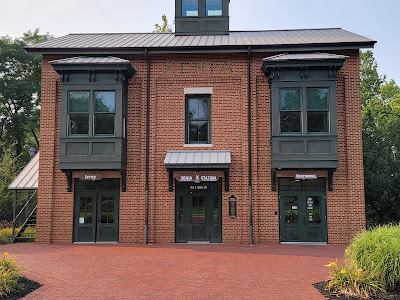
The Miami Valley in Ohio has a network of paved trails that connect ten counties in the valley. Together this makes about 350 miles of trails concentrated on one area. They claim to be the largest network of paved trails in the country and this seems to be reasonable. The hub of this system in a small visitor center called Xenia Station in the town of Xenia. This concentration of trails has made Xenia a popular destination for cyclists that prefer to ride trails.
Before I traveled there I pictured a
small town of a few hundred people. I arrived to find a much larger community
of over 26,000 people. The Little Miami Trail connects to the Ohio to Erie
Trail in Xenia. In addition to these major trails the Creekside Trail also ends
at Xenia Station. That means you can go in five different directions from Xenia
Station. All these trails in turn connect to other trails across the Miami
Valley.
The trails are identified on maps and
signs by numbers. The Ohio to Erie is number 1. The Creekside is number 2. The
Little Miami uses both #1 and #3. #3 is also the designation of the Simon
Kenton Trail. Most of these trails are also part of the US bicycle route
designation with an additional numeric designation.
The trails use mile markers that start
with Xenia Station as mile zero. This can be a bit confusing if the trail does
not start/end in Xenia. That is a bit of a moot point since the markers are
painted on the center of the trail surface and almost all are not legible.
Generally these trails are paved, about
12 feet wide with an additional grassy shoulder. The surface is very smooth.
The trails are very straight and flat. Exceptions are at road crossings where
the trails usually turn a bit so they cross perpendicular to the road. This
makes it easier to see in both directions.
More information including a detailed
map may be found at the Miami Valley Regional Planning Commission website mvrpc.org/bikeways

No comments:
Post a Comment